
- Plan, book, fly with confidence
- Be in the knowGet alerts if flight prices drop or rise*
- Book smarterSave on select hotels after you book a flight*
- Find the right fitWe search billions of combinations of flights to help you find your next adventure
Hotels near Marsh Harbour Airport

Marsh Harbour
Stay at this vacation home in Marsh Harbour. Enjoy free WiFi, private pools, and a garden. Popular attractions Abaco Beach and Abaco Marina are located ...
10/10 Exceptional! (8 reviews)
Bay Street, Marsh Harbour, Abaco
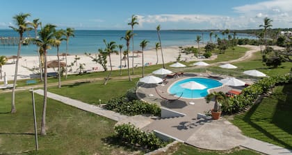
Stay at this 3.5-star beach resort in Marsh Harbour. Enjoy 2 outdoor pools, 2 restaurants, and a private beach. Popular attractions Abaco Beach and Abaco Marina ...
8/10 Very Good! (291 reviews)

Great Cistern Beach Road, Marsh Harbour, Central Abaco
The price is SAR 844 per night from May 17 to May 18
SAR 844
SAR 1,021 total
includes taxes & fees
17 May - 18 May
Stay at this 3-star beach cottage in Marsh Harbour. Enjoy free WiFi, free parking, and a beach locale. Popular attractions Marsh Harbour and Abaco Beach are ...
9.2/10 Wonderful! (14 reviews)
Lowest nightly price found within the past 24 hours based on a 1 night stay for 2 adults. Prices and availability subject to change. Additional terms may apply.
Travel information
Travel information
Marsh Harbour Airport
Current conditions at Marsh Harbour International Airport
Show map
Airport Information
Name: Marsh Harbour International Airport
Location: Marsh Harbour, Bahamas
- Longitude: 26.513428
- Latitude: -77.077119
Airport Codes:
- IATA: MHH
- ICAO: MYAM
Explore a world of travel with Expedia
Explore a world of travel with Expedia
- Flights from Caribbean Islands
- Flights from Hope Town
- Flights from Treasure Cay
- Flights from Marsh Harbour
- Flights from Abaco Islands
- Flights from Elbow Cay
- Flights from Green Turtle Cay
- Flights from Grand Bahama
- Flights from Great Guana Cay
- Flights from Man O War Cay
- Flights from Great Abaco Island
- Flights from Cherokee
Nearby Airports
- Treasure Cay Airport (TCB)
- Great Harbour Cay Airport (GHC)
- North Eleuthera Intl. Airport (ELH)
- Governor's Harbour Airport (GHB)
- Grand Bahama Intl. Airport (FPO)
- Lynden Pindling Intl. Airport (NAS)
- Rock Sound Intl. Airport (RSD)
- North Seaplane Base Airport (NSB)
- South Bimini Island Airport (BIM)
- Arthur's Town Airport (ATC)